Connect with us

Technology

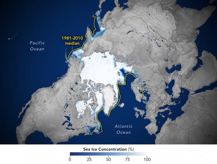
NASA records 6th lowest Arctic sea ice, low growth in Antarctic ice cover

Image
Image

Washington, Sep 27
Rising global temperatures caused Arctic sea ice to reach its annual minimum extent on September 19, making it the sixth-lowest year in the satellite record, according to researchers at NASA and the National Snow and Ice Data Center (NSIDC).

The findings, made using satellite data, showed that between March and September, the ice cover in the Arctic shrank from a peak area of 14.62 million square kilometres to 4.23 million square kilometres.

That’s roughly 1.99 million square kilometres below the 1981-2010 average minimum of 6.22 million square kilometres. The amount of sea ice lost was enough to cover the entire continental US, said the researchers.

This year in the Arctic, scientists saw notably low levels of ice in the Northwest Passage, said Walt Meier, a sea ice scientist at NSIDC.

“It is more open there than it used to be. There also seems to be a lot more loose, lower concentration ice -- even toward the North Pole -- and areas that used to be pretty compact, solid sheets of ice through the summer. That’s been happening more frequently in recent years.”

Meier said the changes are a fundamental, decades-long response to warming temperatures. Since the start of the satellite record for ice in 1979, sea ice has not only been declining in the Arctic, but also getting younger.

Nathan Kurtz, lab chief of NASA’s Cryospheric Sciences Laboratory at the agency’s Goddard Space Flight Center in Greenbelt, Maryland, said that as the Arctic warms about four times faster than the rest of the planet, the ice is also growing thinner.

Antarctic sea ice also reached its lowest maximum extent on record on September 10 at a time when the ice cover should have been growing at a much faster pace during the darkest and coldest months, said the teams from NASA and NSIDC.

Sea ice around Antarctica reached its lowest winter maximum at 16.96 million square kilometres. That’s 1.03 million square kilometres below the previous record-low reached in 1986 -- a difference that equates to roughly the size of Texas and California combined, they noted.

The average maximum extent between 1981 and 2010 was 18.71 million square kilometres.

Meier said: “It’s a record-smashing sea ice low in the Antarctic. Sea ice growth appears low around nearly the whole continent as opposed to any one region.”

Scientists are working to understand the cause of the meagre growth of the Antarctic sea ice, which could include a combination of factors such as El Nino, wind patterns, and warming ocean temperatures. New research has shown that ocean heat is likely playing an important role in slowing cold season ice growth and enhancing warm season melting.